Cherokee National Forest · Backbone Rock Recreation Area, Tennessee
Backbone Rock Trail #53 at Cherokee National Forest
Backbone Rock Trail #53 at Cherokee National Forest: 4 mi.
Updated Oct 27, 2026 · Source-verified by TennesseeHikes
- Distance
- 4 mi
On this page
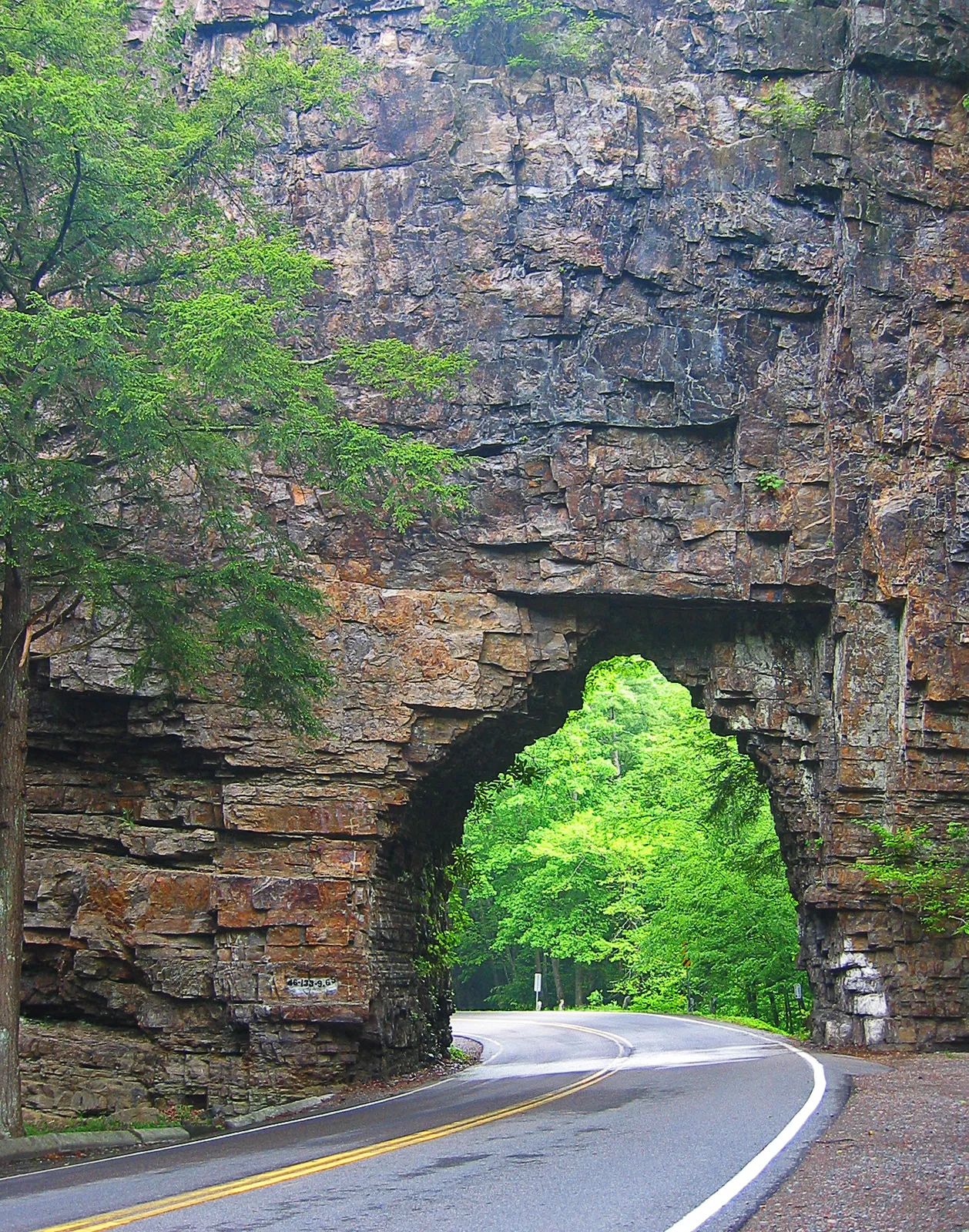
Backbone Rock Tunnel near Shady Valley, Tennessee, photo by pfly, CC BY-SA 2.0, via Wikimedia Commons.
Backbone Rock Trail #53 starts at Backbone Rock Recreation Area on Beaverdam Creek in northern Johnson County. Backbone Rock is a spur ridge of Holston Mountain that ends abruptly at a bend in the creek. A tunnel drilled in 1901 carried the railroad between Shady Valley and Damascus, Virginia. Motorists on TN 133 drive through it, “The Shortest Tunnel in the World.”
In the 1930s the Civilian Conservation Corps built the day-use area, two picnic shelters, and hiking trails in native stone. The campground was added in the 1960s and rehabilitated in the mid-1990s. The photo is the tunnel, not the tread.
Quick facts
- Forest Service listing: 4 miles, ending at the Appalachian National Scenic Trail. Trailhead about a quarter mile south of the campground on TN 133 (Backbone Rock Campground on Recreation.gov).
- Mapped line: 2.38 mi on this site. Do not average the two figures. The listing does not print 2.38.
- Elevation gain: not stated.
- Nearby: Backbone Falls Trail #198, about a third of a mile south of the campground. A 0.4-mile loop with rock steps, walkways, and views of 45-foot Backbone Falls.
- Hours: gates 7am–10pm. Trails open year-round, sunrise to sunset.
- Campground: 8 singles $10/night, 2 doubles $20/night, roughly late April to mid-October. Closed for 2026.
- Day use: vault toilet open until the third Monday in November. Potable water is listed. Beaverdam Creek is stocked with trout.
- Rules: pets on a 6-ft leash maximum; no alcohol; Cherokee National Forest food storage order (bear-proof storage). Group permit only for 75+. Phone 423-735-1500.
- Not stated: a day-use parking fee.
Getting There
From Bristol, go US 421 south 20 miles to Shady Valley, then left on TN 133 for 8 miles.
From Abingdon, Virginia, go US 58 east 15 miles to Damascus, then right on VA 716 for 5 miles. VA 716 becomes TN 133 at the state line.
The #53 trailhead is about a quarter mile south of the campground on TN 133. Falls Trail #198 is about a third of a mile south of the campground. TN 133 passes through the 1901 tunnel.
Gates open at 7am and close at 10pm. Be out by sunset; trails are sunrise to sunset all year. The day-use vault toilet stays open until the third Monday in November, and potable water is listed at the site.
The Trail
Forest Service listing: 4 miles to the Appalachian Trail. This site’s mapped line: 2.38 mi. Do not average them. No elevation gain is stated.
The trailhead is about a quarter mile south of the campground on TN 133. The trail ends where it joins the Appalachian National Scenic Trail. No official round trip is listed. Stone steps near the rock can be rocky and slick when wet. Stay on the trail near drop-offs. That stonework is from the Civilian Conservation Corps trails of the 1930s.
Backbone Falls and camping
Trail #198 is a separate walk, about a third of a mile south of the campground. It is a 0.4-mile loop with rock steps, walkways, and viewpoints of 45-foot Backbone Falls. Do not add 0.4 to the 4-mile listing.
Eight single sites cost $10 per night and two doubles cost $20, roughly late April to mid-October. The campground is closed for 2026. The day-use vault toilet stays open until the third Monday in November. Potable water is listed, and Beaverdam Creek is stocked with trout.
Rules
Pets need a leash no longer than 6 feet. Alcohol is prohibited. The Cherokee National Forest food storage order requires bear-proof storage. Groups need a special use permit only at 75 people or more. Call 423-735-1500. Check Cherokee National Forest alerts before you go. No day-use parking fee is stated here.
Tips
Wet stone steps near the rock are slick, and the footing is rocky. Stay on the trail beside drop-offs. No other hazards are listed here.
Skip camping plans for 2026. The single and double sites are closed for the season. Day-use gates remain 7am to 10pm, and trails stay sunrise to sunset. Read the alerts page the morning you leave.
Sources
- Backbone Rock Recreation Area (USDA Forest Service): Beaverdam Creek, the 1901 tunnel, CCC stonework, hours, rules, water, trout, and driving directions.
- Backbone Falls Hike (USDA Forest Service): Trail #198, a 0.4-mile loop a third of a mile south of the campground, with views of 45-foot Backbone Falls.
- Backbone Rock Campground (Recreation.gov): Trail #53 at 4 miles to the Appalachian Trail; trailhead a quarter mile south of the campground; fees, season, and the 2026 closure.
- Cherokee National Forest alerts: check before going.
- This site: mapped 2.38 mi, not an official length.
- Photo: pfly, CC BY-SA 2.0, via Wikimedia Commons (credit under the image).
FAQs
How long is Backbone Rock Trail #53?
4 miles on the Forest Service listing, to the Appalachian Trail. This site’s mapped line is 2.38 mi. Do not average them. No elevation gain is stated.
How do you reach the trailhead?
It is about a quarter mile south of the campground on TN 133. From Bristol, US 421 south 20 miles to Shady Valley, then TN 133 for 8 miles. From Abingdon, US 58 east 15 miles to Damascus, then VA 716 for 5 miles to the state line, where the road becomes TN 133.
Is the campground open in 2026?
No. The 8 single sites ($10/night) and 2 doubles ($20/night) are closed for 2026. In a normal year the season is roughly late April to mid-October. Trails remain sunrise to sunset, and the vault toilet stays until the third Monday in November.
What are the day-of rules?
Use a leash of 6 feet or less, bring no alcohol, and store food bear-proof. A group permit is required only for 75 or more people. Call 423-735-1500, and check forest alerts before you go.